Now Reading: Top land use planning hyderabad – 2025 Guide
-
01
Top land use planning hyderabad – 2025 Guide

Introduction: Why Land Use Planning in Hyderabad Matters in 2025
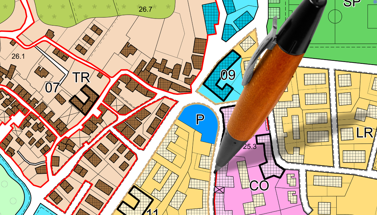
In 2025, land use planning Hyderabad has emerged as a critical factor shaping the future of real estate development, infrastructure, and sustainable urban growth. With Hyderabad’s population crossing 12 million and urban expansion accelerating toward peripheral zones, systematic land use planning is more relevant than ever.
From strategic zoning to balanced integration of residential, commercial, and green spaces, land use planning Hyderabad is not just a regulatory process it’s the blueprint for smart city evolution, guided by the Hyderabad Metropolitan Development Authority (HMDA) and Greater Hyderabad Municipal Corporation (GHMC). For investors, developers, and homebuyers, understanding land use norms is key to unlocking profitable and sustainable opportunities.
Key Trends in Land Use Planning Hyderabad – 2025
1. Transit-Oriented Development (TOD)
- Areas near metro corridors (Nagole to Miyapur, LB Nagar to Raidurg) are witnessing integrated land use development.
- Mixed-use zoning is being implemented to encourage walkable neighborhoods near transit hubs.
2. Peripheral Growth Corridors
- Rangareddy, Maheshwaram, Shadnagar, and Shamshabad are benefiting from revised land use policies that promote industrial and logistics zones.
- Land pooling and integrated township planning are part of new initiatives in HMDA’s extended areas.
3. Green Zoning and Environmental Compliance
- With the Environmental Clearance (EC) guidelines evolving, land use planning Hyderabad now mandates 10% of space be dedicated to green cover for major layouts.
- Lake buffer zones (like Durgam Cheruvu, Hussain Sagar) have stricter planning norms for ecological protection.
Top Areas Influenced by Land Use Planning in Hyderabad
1. Kokapet – Neopolis Layout
- Planned under the Telangana Government’s master plan for high-rise commercial and residential zones.
- World-class infrastructure, roads, and clear land titles attract MNCs and luxury developers.
2. Pharma City – South Hyderabad
- 19,000+ acres earmarked for industrial use.
- Supports bulk drug manufacturing zones with restricted residential development.
3. Financial District Expansion – Gachibowli
- Revised zoning norms allow vertical expansion.
- Greater emphasis on commercial land use aligned with IT/ITES sector growth.
4. ORR Growth Corridor
- 1-km buffer around the Outer Ring Road (ORR) categorized for mixed-use and IT-enabled services.
- Land use planning supports co-living, co-working, and affordable housing projects.
Challenges in Land Use Planning, Hyderabad
Despite clear policy frameworks, land use planning in Hyderabad faces the following hurdles:
- Unauthorized Layouts: Many peripheral areas still struggle with unauthorized layouts lacking basic infrastructure.
- Delayed Master Plan Revisions: Some regions operate on outdated planning norms, confusing buyers and developers.
- Environmental Conflicts: Encroachments on lakebeds and green zones lead to legal disputes and halt project progress.
Future Outlook: What to Expect from Land Use Planning in Hyderabad
By 2030, Hyderabad aims to be a top-tier global city, and land use planning in Hyderabad is central to that vision. Upcoming plans include:
- Integrated Master Plan 2041 by HMDA with AI-based spatial planning tools.
- Smart zoning platforms for real-time land-use approvals.
- More transparency with GIS-based land records and e-clearances.
For real estate investors and builders, aligning with land use norms early will offer higher ROI, faster approvals, and enhanced credibility.
FAQs on Land Use Planning Hyderabad
Q1. What is land use planning in Hyderabad?
Land use planning Hyderabad refers to the strategic regulation and allocation of land for residential, commercial, industrial, and recreational use, guided by the city’s master plan.
Q2. Who governs land use planning in Hyderabad?
The Hyderabad Metropolitan Development Authority (HMDA) and GHMC are the key regulatory bodies overseeing land use planning Hyderabad.
Q3. Why is land use planning important for investors?
Understanding zoning regulations and land use categories helps investors avoid legal issues, ensures proper approvals, and increases the project’s value.
Q4. Which areas in Hyderabad are seeing major land use planning changes in 2025?
Kokapet, Pharma City, Shamshabad, and areas along the Outer Ring Road are experiencing major zoning transformations.
Q5. How can I check the land use zone of a particular plot in Hyderabad?
You can verify the land use zoning of any plot via the HMDA website or GIS-based platforms provided by the Telangana Government.
Conclusion
As Hyderabad’s skyline continues to evolve, land use planning Hyderabad remains at the heart of responsible urban development. Whether you’re a homebuyer exploring emerging corridors, an investor seeking clarity on zoning laws, or a developer planning large-scale projects, staying informed about land use trends is non-negotiable in 2025.Keep visiting RealtyDataHub.com for accurate, updated, and expert-driven real estate insights.


Related Posts


Stay Informed With the Latest & Most Important News
Previous Post
Next Post
Previous Post

Next Post


Advertisement